WV State XC Championship
2021 Date TBD
Location: Cabell-Midland High School
2300 U.S. Route 60 East, Ona, WV 25545
TICKETS:
SPECTATORS:
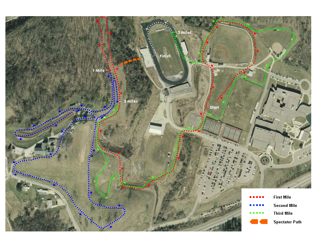
Course Map:

Course Elevation:

Course Elevation Grade Percentage:

Course Description:
Cabell Midland’s cross country course offers a balanced combination of hills and flats that is one of the best groomed courses in the state. The course runs on the campus of Cabell Midland High School and the Cabell County Farm. It is very spectator friendly and allows coaches to monitor the action closely for the majority of the race.
The course starts on the field, located between the school and the track stadium. The start is flat, with a gentle turn at the end of the soccer field fence that takes the runners around the baseball stadium.
The runners reenter the practice field area and continue along the sideline, where spectators standing on the road way line the fence. They then turn right, crossing the access road and dropping into a small dip that takes them onto the band field. The runners run along the edge of the field until they reach the first and toughest climb of the course. The hill begins with a short, steep accent onto the path, then turns right and climbs for the next 300 meters before leveling into the horseshoe. Once in the horseshoe, the course takes the runners back through the woods, and then reverses back into the clearing, bringing the runners to the first mile marker.
After the mile marker, the athletes run for another 50 meters before turning right and descending behind the barn. They then reach a flat path that takes them on a loop through a field, ending at the base of the next climb. The runners climb the hill, running around the front side of the house before connecting to the gravel path. The gravel section begins with a short, steep descent with a sharp left turn at the bottom before leveling, taking the runners around the side of the hill parallel to Howell’s Mill Road. After another downhill, the path moves upward once more for the final climb, ending as the runners lap around a small cemetery.
The runners continue on the path back towards the barn, returning the runners to the horseshoe. After making a small loop back in the horseshoe that ends just before the 1 mile marker, the runners come through 2 miles.
The final mile of the course is either downhill or flat, making it very fast. Almost immediately following the 2 mile marker the runners start down the hill. They go about half-way before reaching a short hill that takes them on a short downhill loop around the pond. From there, they continue down the hill, running the same path that they did during the first mile, taking them back to the start area.
Upon reaching the start area, the runners turn right and run along the fence line until they reach the softball stadium. The runners run behind the softball stadium then veer to the right and round the baseball stadium again. They then drop back into the dip and round Gabriel’s Curve, turning right and entering the football stadium. The runners complete the final 200m on the "Chris Parsons Track", finishing at the 50m line in front of the main bleachers.
2020 Slideshow


